
1756 Chart of the Florida Keys
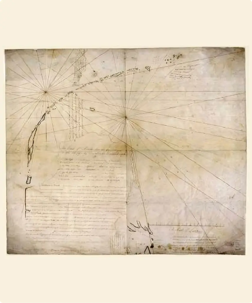
Using a combination of skills acquired during a maritime career on which he embarked at an early age as an apprentice on his father's boat, Captain David Cutler Braddock charted the vast area of lower Florida and the Keys onto vellum, a parchment made from calfskin, lambskin, or kidskin. The chart, on which he states he and four other vessels are from New Providence in the Bahamas, is in the Library of Congress in Washington. He was in the Keys as a privateer, lying in wait for unsuspecting Spanish vessels heading home laden with Mexican treasures.
The full-size chart measures 23 ―" by 26". The accompanying snapshot does little justice to the two-and-a-half centuries-old chart, for the most part legible detail.
As can be seen, the chart is oriented with the south at the top.
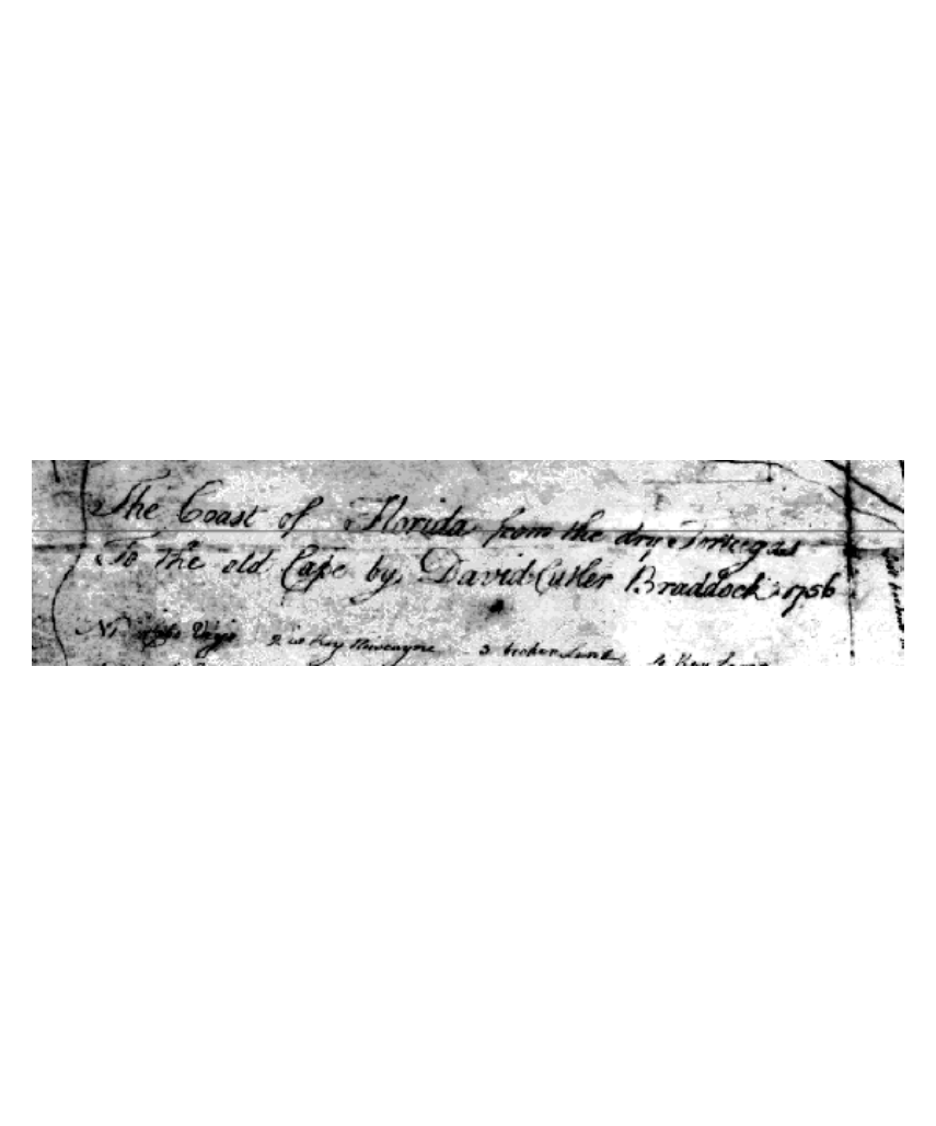
The chart's title, authorship, and date are declared on the first two horizontal lines nearest the tip of mainland Florida:
The Coast of Florida from the Dry Tortugas
To the Old Cape by David Cutler Braddock, 1756
Not all geographical points on the chart are identified. Those that are identified are labeled with numbers. The numbers and associated names are listed after the above title.
Most names shown are still in use, some with slightly different spellings or English translations. Loo Key, named after the British man-of-war war wrecked on it in 1744, is among those shown (Ironically, Braddock's father-in-law, noted colonial mariner Captain William Lyford Sr., served as pilot of the Loo in Carolina waters):
N
- Cabo Viejo
- is Key Biscayne
- broken land
- Key Largo
- a turtle Crawle
- the Martieres
- Rodrigo
- Key Tabernere
- Key Mata Cumba Baya
- Agua Key
- Lena Key
- Key Franzois
- Key Mata Comba Mosa
- Bivora Culebras Key
- Key Pata
- Hijos the Caia Vacas
- Key Sombrero
- Bay Hunda
- Key Arena
- Boca Chica
- Double iland [sic]
- Key Loo
- Key West
- Acca keys
- Boca Grande
- Key Aves
- Key Marquis
- Dry Tortugas
- Harbors & Roads. At Kee Biscayne a vesel may anchor with safety the cours in N N W keep close to the spit & you carry in nine feet at high water . . . .you may anchor almost anywhere within the Matieres Reef, but if it blows hard & your vessel draws no more than seven feet at high water run into that opening of Largo where you may ride safe against all storms that ever blow after you are got into the Channel leading in which is near the Spanish C[?] there is water there far the largest Merchant Man. . . . . But if you draw more & you see a nor' wester coming up run to Kee Rodrigo under the shelter of the Key rode the Sloop Bahamian & Schooner two Brothers 1765 when it blew very fresh the ground is clay[?] a little before you come in this Kee is the most [?] [?] part of this coast, within the reef, not being more than fourteen feet water at low water
- Kee Tavernere will afford the like shelter - - - - - Kee Francois will be very safe with the wind from N E to N W but if the wind is likely to chop about run into the Channel to the Eastward of this Kee & shelter from S E or S W. . . . . Kee Sombrero will make smooth riding with the wind from N E to N N W at the Bay of Hunda you will be covered from the winds at S E to S W but at N N W & westerly you are too much aposed[sic].
- You may anchor at Boca Chica which requires a good lookout - - - - - at Key West, you are safe from N E to N W but if it comes from the S E weigh and runs to the wester most of the Rocas within the point & a sandbank lying a quarter of a mile from the point the marks to carry you in is brought the nor' west Kee on the bank and a mangrove bush open with the point of the wester most Rocas giving the point of the Kee a birth for a reef that lyeth of the S E part of it when you have these points open you may haul up for the inner point of the Kee & run as far as you like up that Channel - - - - - you may anchor under the N W point of the Marquis When you make the Tortuga's give the Easter most Kees a good offing by hauling to the Southward and then run in with the arrows[arrows indicating the course are on the chart]. they are very low and sandy without even a tree.
There are a[sic] several good channels through the Martieres & so there is to the Southwest of them.
Cape passage southward of Biscayne lies in Latt, 25:20 . . .
A Scale of Leagues
Capt Braddock in 1756 in Company with four other vessels from new Providence in a gale of wind ran into the Southernmost Channels then found three fathoms in but on coming out had only nine feet from side to side which he supposed owing to a shift of wind at that time. The soundings of the northernmost part of the Bay our author is not acquainted with but saw Spanish vessels that fish for Mullet of the Havanna working there & that it looked like deep water.
Boca Grande is not Northerly enough by four or five miles, and the reason for this is very evident. The scale is just twice as long as the rest of the chart, for instance, Two leagues of the chart are but one here.
Within the Harbor is Written:
Boca Grande
Latt. 27:10
On one of the several points of land in the harbor is written:
D. Comfort
On another that is labeled on modern maps as having Indian mounds is written:
Oyster bank